 shared
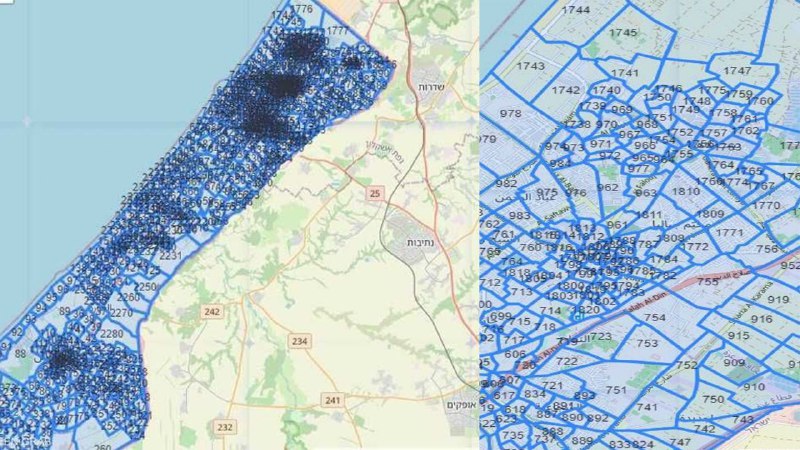
Enclave divided into numbered ‘blocks’ to order civilians to move ahead of attacks as Israel launches new phase of war.
The Israeli army on Friday published a map of so-called “evacuation zones” in the Gaza Strip as the war on the enclave resumed following a temporary humanitarian pause.
The map divides the besieged enclave into “blocks” in preparation for a new phase of the war. The map would determine the army’s targets to allow civilians to leave those areas before the attacks take place.
Civilians were asked to identify their areas of residence according to the numbered blocks marked on the map.
Based on the plan, the Israeli army will determine in advance the areas it will attack and will ask the residents to leave, as it claimed.
“The blocks map divides the land of the Gaza Strip into regions and neighborhoods,” Avichay Adraee, spokesman for the Israeli army, said in a video.
Conveying his message to Gazans, the spokesman said: “This map will help you in the later stages of the war to understand our instructions and move (from residential areas) when necessary, from certain places if you are asked to do so.”
“We will make every effort to evacuate only to the relevant block numbers in the call to move to other areas,” he said.
Adraee added that the Israeli army “will continue to publish evacuation instructions repeatedly through the media.”
Adraee called on citizens in Gaza to review the map that was published on the Israeli army’s website, and “to become familiar with your area of residence and the relevant block numbers and to move from your area of residence according to the instructions in the event that you receive an official warning in this regard from the Israeli army.”
For its part, the Israeli army said in a separate statement that “the published map shows the numbers of evacuation zones (blocks) in the north and south of the strip, with a call to residents to find the block relevant to their place of residence and to act if they are asked to move from it.”
The evacuation areas, the army said, would be determined through letters and leaflets that would be sent to the residents of Gaza.
Through the messages, residents will be directed to evacuate specific areas and move through the corresponding streets, it added.
The Israeli army claimed that by doing so it wanted to “avoid causing loss of civilian lives.”
“The map was published on a special page on the Israeli army’s website in Arabic, and the map was published in leaflets distributed by the army in the Gaza Strip,” the army added.
